


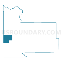
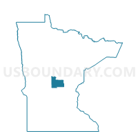
Culdrum Township Voting District, Morrison County, Minnesota
About
Outline

Summary
| Unique Area Identifier | 603191 |
| Name | Culdrum Township Voting District |
| County | Morrison County |
| State | Minnesota |
| Area (square miles) | 33.86 |
| Land Area (square miles) | 33.63 |
| Water Area (square miles) | 0.23 |
| % of Land Area | 99.32 |
| % of Water Area | 0.68 |
| Latitude of the Internal Point | 45.98219960 |
| Longtitude of the Internal Point | -94.58768200 |
Maps

Graphs
Select a template below for downloading or customizing gragh for Culdrum Township Voting District, Morrison County, Minnesota


Neighbors
Neighoring Voting District (by Name) Neighboring Voting District on the Map
- Bruce Twp. Voting District, Todd County, MN
- Burnhamville Twp. Voting District, Todd County, MN
- Darling Township Voting District, Morrison County, MN
- Flensburg Voting District, Morrison County, MN
- Little Elk Twp. Voting District, Todd County, MN
- Parker Township Voting District, Morrison County, MN
- Pike Creek Township Voting District, Morrison County, MN
- Swanville Township Voting District, Morrison County, MN
Top 10 Neighboring County Subdivision (by Population) Neighboring County Subdivision on the Map
- Pike Creek township, Morrison County, MN (953)
- Burnhamville township, Todd County, MN (759)
- Bruce township, Todd County, MN (585)
- Darling township, Morrison County, MN (535)
- Swanville township, Morrison County, MN (517)
- Culdrum township, Morrison County, MN (487)
- Parker township, Morrison County, MN (474)
- Little Elk township, Todd County, MN (285)
- Flensburg city, Morrison County, MN (225)
Top 10 Neighboring Place (by Population) Neighboring Place on the Map
Top 10 Neighboring Unified School District (by Population) Neighboring Unified School District on the Map
Top 10 Neighboring State Legislative District Lower Chamber (by Population) Neighboring State Legislative District Lower Chamber on the Map
Top 10 Neighboring State Legislative District Upper Chamber (by Population) Neighboring State Legislative District Upper Chamber on the Map
Top 10 Neighboring 111th Congressional District (by Population) Neighboring 111th Congressional District on the Map
Top 10 Neighboring Census Tract (by Population) Neighboring Census Tract on the Map
- Census Tract 7808, Morrison County, MN (4,306)
- Census Tract 7802, Morrison County, MN (4,063)
- Census Tract 7904, Todd County, MN (3,468)
- Census Tract 7905, Todd County, MN (2,653)